Portable weather and camera station for TasParks
Client: Department of Natural Resources and Environment Tasmania, Tasmania Parks and Wildlife Service
Location: Tasmania, Australia
Date: Nov 2021 - July 2022
Designing a portable telemetered camera and weather station to support Tasmania Parks and Wildlife Service’s remote operations
Background
Tasmania Parks and Wildlife Service (PWS) manages 49 per cent of Tasmania’s land area, covering more than 2.9 million hectares of land and water. Much of this area is remote and rugged, so management operations can be expensive and result in risk to personnel and assets.
To support PWS to conduct safe and efficient operations in these landscapes, Entura was engaged to design a portable remote camera and telemetry system able to take images at the installation site. Images could then be fed back to PWS for personnel to remotely assess the site conditions and make informed decisions about carrying out operations.
Solution
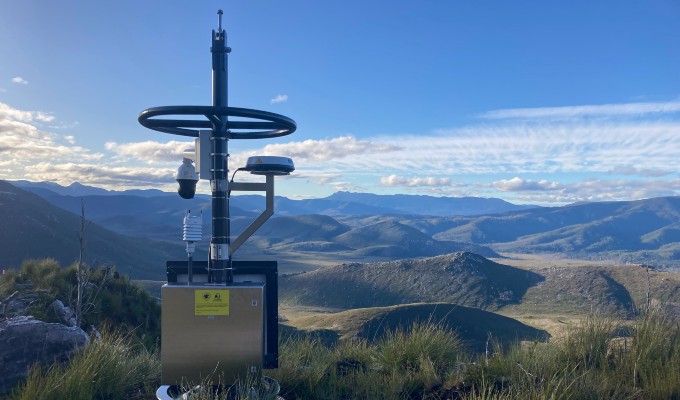
Entura’s digital experts and PWS worked collaboratively on a portable system to suit PWS’s specific needs, requiring a camera to capture high-resolution imagery, a weather station to report local conditions and a communications system to transport data and imagery back to a dashboard.
The device was conceptualised for use in Tasmania’s Southwest National Park, beginning with a desktop analysis to determine the optimal mode of communication. Entura’s analysis found that NB-IoT and 4G coverage in the area was poor, with satellite identified as the optimal communication system for the large data packets required.
An initial design comprised a portable package that could be transported to site via helicopter, deployed and assembled on the ground, with a satellite attached. A number of features with potential for optimisation were identified in this design, which led the team to pivot towards a different model.
Our team worked with PWS and Heli Resources to employ an auto-loc winching mechanism that would allow a helicopter to deploy the system, removing the need for on-ground personnel and assembly. This made the second iteration portable and instantly deployable, allowing for easier, less risky and more cost-effective installation. The system is fitted with weather-monitoring instrumentation in a protective enclosure below a crash bar and a high-resolution camera.
Finding an appropriate satellite terminal to feed large image files back into Entura’s Ajenti Data Management System (ADMS), without the need for on-site calibration and large amount of power generation, posed a significant challenge. The satellite terminal adopted was a power-friendly, off-the-shelf product often used on buses and trains to provide wi-fi to passengers. It can be run entirely off a small off-grid solar power system attached to the structure.
Services provided
- desktop analysis
- detailed design
- installation
- data management
Outcome
The first installation was successfully completed in July 2022. The device captures high-resolution images and relevant weather data and feeds it back to PWS to inform safe and efficient helicopter operations. It will remain in the Southwest National Park while track works are taking place, before being relocated for other operations.
The portable equipment has allowed PWS to have a small site footprint, and flexibility to site the unit to minimise visual impact in a wilderness location. By checking conditions prior to helicopter operations, PWS can save time, money and resources that would otherwise be lost travelling to site and having to turn back in bad weather. It also helps to avoid risks associated with accessing these remote and often rugged areas.
These devices could also be adapted to be used in future for bushfire detection, which could provide an extra, and significant, benefit by protecting and preserving landscape and helping to keep communities safe.

